
A living shoreline is a method of land stabilization that protects the shoreline from erosion while also preserving, enhancing, or creating habitat, and maintaining connectivity between land and water.
There are many different living shoreline techniques, yet they all generally employ natural or biodegradable materials such as stones, sand, oyster shells, or coconut fiber (coir) logs. These materials are typically used in conjunction with planting of native species in order to stabilize the shoreline, foster habitat, and improve the aesthetics of an area. Living shorelines are an attractive alternative to traditional “hard” structures such as seawalls or bulkheads, which destroy habitat and sever the connection between the coast and water.
Along with shoreline stabilization and habitat creation/enhancement, additional benefits of living shorelines include improved water quality, better flood mitigation, improved aesthetics, and increased opportunities for recreation.
Along with shoreline stabilization and habitat creation/enhancement, additional benefits of living shorelines include improved water quality, better flood mitigation, improved aesthetics, and increased opportunities for recreation.
| living_shorelines.ppsx |
Projects
|
South Riverside DriveNeptune Township is constructing a 2,050-foot-long living shoreline along South Riverside Drive. Living shorelines are nature-based solutions that provide land stabilization and protect shorelines from erosion while also creating or enhancing living space for other organisms.
Overall, this project will help protect the surrounding community from storms and waves, reduce flooding impacts, and create marsha and beach habitat for wildlife. Construction work is being carried out by Neptune Township and Albert Marine, Inc. Avakian Engineering is managing the construction, while the Society is providing ecological oversight to ensure minimal disruption of existing habitat during the project. For more information and updates, go to the project page. |
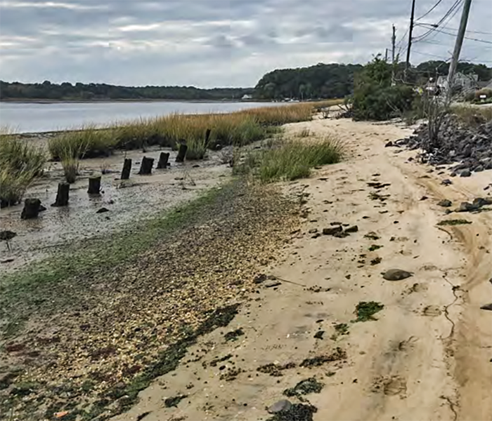
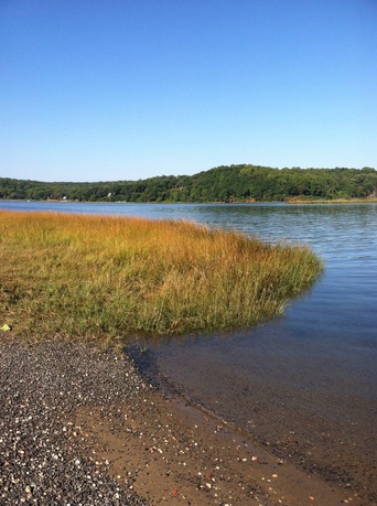
Slade Dale SanctuarySlade Dale Sanctuary is a 12.93 acre preserve located along Beaverdam Creek in Point Pleasant, NJ. Historic aerial imagery shows the shoreline to have eroded an average of approximately 300 feet since 1930, and the current vegetation composition of the site shows evidence of marsh retreat. To halt this erosion and regain marsh habitat, this project involves the construction of a branchbox breakwater and several Christmas tree vanes, as well as the planting of native species.
|
|
|
|
Rumson Boat Ramp |
|
The Society is working with the Borough of Rumson to upgrade the municipal boat ramp. While in the preliminary stage, the project may involve the implementation of a living shoreline to expand the existing marsh, as well as upland improvements including the reorganization of traffic flow, upland planting, and the creation of an educational/sitting area.
|
|
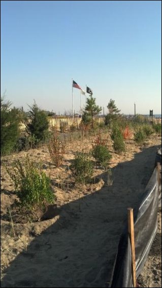
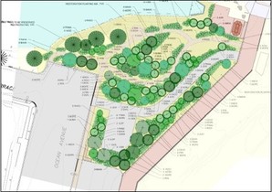
Bradley Beach Maritime Forest
Want to know more about this project? Check out this PowerPoint.
|
The Society was instrumental in the design and construction of the Bradley Beach Maritime Forest. Maritime forests are coastal forests found landward of dune systems. These important areas serve as habitat for a number of unique animals and plants. This project converted a 0.4 acre dirt lot previously used for parking and equipment storage into a maritime forest planted with native vegetation. In total, this project will assist in providing storm protection to local residents, decrease the amount of runoff by increasing groundwater infiltration, provide habitat and increase biodiversity, improve water quality of the adjacent lake by providing natural vegetated buffer strips along the shoreline by the flume, and most importantly, provide outreach and environmental interaction in an area that is heavily trafficked by people.
|
FORKED RIVER BEACH LIVING SHORELINE PROJECT |
Historically, Barnegat Bay had over 12,000 acres of eastern oyster (Crassostrea virginica) beds. Yet today, nearly the entire natural oyster population is gone. With their elimination, Barnegat Bay not only lost the oysters themselves, but the ecosystem services they provided such as water filtration, wave energy mitigation, and nursery habitat.
This project will create seven oyster reefs in Barnegat Bay. The reefs will be located approximately 100-200 feet offshore and run from near the mouth of Forked River in the north, to a lagoon located at the southern end of Beach Boulevard.
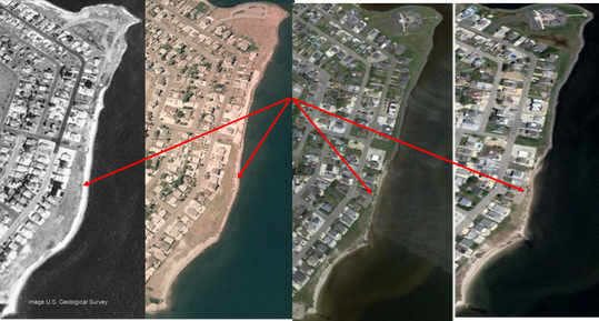
This section of Forked River, known as Forked River Beach, has lost over a hundred feet of shoreline since 1995. Further, the erosion rate is accelerating: abut 20 feet of shoreline were lost in 2017 alone.
Project goals are:
• Improve Water Quality—individual oysters can filter up to 50 gallons of water a day. During this process, they remove excess nutrients and sediment from the water column creating cleaner water.
• Prevent Erosion—the oyster reefs will buffer waves before they reach the shore, reducing their energy and impact, and helping to keep sand on the beach.
• Create Habitat—Oyster reefs create habitat for animals such as crabs and snails, and serve as important spawning, nursing, and foraging grounds for finfish.
Learn more on the project page.
This project will create seven oyster reefs in Barnegat Bay. The reefs will be located approximately 100-200 feet offshore and run from near the mouth of Forked River in the north, to a lagoon located at the southern end of Beach Boulevard.
This section of Forked River, known as Forked River Beach, has lost over a hundred feet of shoreline since 1995. Further, the erosion rate is accelerating: abut 20 feet of shoreline were lost in 2017 alone.
Project goals are:
• Improve Water Quality—individual oysters can filter up to 50 gallons of water a day. During this process, they remove excess nutrients and sediment from the water column creating cleaner water.
• Prevent Erosion—the oyster reefs will buffer waves before they reach the shore, reducing their energy and impact, and helping to keep sand on the beach.
• Create Habitat—Oyster reefs create habitat for animals such as crabs and snails, and serve as important spawning, nursing, and foraging grounds for finfish.
Learn more on the project page.
Restoration Explorer
Historically, Barnegat Bay had over 12,000 acres of eastern oyster (Crassostrea virginica) beds. Yet today, nearly the entire natural oyster population is gone. With their elimination, Barnegat Bay not only lost the oysters themselves, but the ecosystem services they provided such as water filtration, wave energy mitigation, and nursery habitat.
This project will create seven oyster reefs in Barnegat Bay. The reefs will be located approximately 100-200 feet offshore and run from near the mouth of Forked River in the north, to a lagoon located at the southern end of Beach Boulevard.
This section of Forked River, known as Forked River Beach, has lost over a hundred feet of shoreline since 1995. Further, the erosion rate is accelerating: abut 20 feet of shoreline were lost in 2017 alone.
Project Dates: April 1, 2014 – March 31, 2016
Through a National Oceanic and Atmospheric Administration (NOAA) post-Sandy grant awarded to the Nature Conservancy (TNC), the Society worked closely on the NJ Resilient Coastlines Initiative with a number of partners including the New Jersey Department of Environmental Protection, Rutgers University, Stevens Institute of Technology, Partnership for the Delaware Estuary, Barnegat Bay Partnership, NOAA National Marine Fisheries Service (NMFS), USFWS, and US Geological Survey. The goals of the project were to provide statewide shoreline protection and habitat enhancement. An online map-based tool called the "Restoration Explorer" was developed as part of this project and can be found on TNC's CoastalResilience.org website. As part of this project, the Society aided Monmouth County municipalities in developing nature-based resiliency strategies and participated in the development of a statewide monitoring framework for living shoreline projects.
Through a National Oceanic and Atmospheric Administration (NOAA) post-Sandy grant awarded to the Nature Conservancy (TNC), the Society worked closely on the NJ Resilient Coastlines Initiative with a number of partners including the New Jersey Department of Environmental Protection, Rutgers University, Stevens Institute of Technology, Partnership for the Delaware Estuary, Barnegat Bay Partnership, NOAA National Marine Fisheries Service (NMFS), USFWS, and US Geological Survey. The goals of the project were to provide statewide shoreline protection and habitat enhancement. An online map-based tool called the "Restoration Explorer" was developed as part of this project and can be found on TNC's CoastalResilience.org website. As part of this project, the Society aided Monmouth County municipalities in developing nature-based resiliency strategies and participated in the development of a statewide monitoring framework for living shoreline projects.
Living Shorelines Academy
The American Littoral Society is focused on providing waterfront property owners with better, more environmentally beneficial alternatives for dealing with shoreline erosion problems. The Society has projects and programs aimed at:
About 14 percent of the bays, and coastal waterways in the U.S. are hardened by bulkheads and other hard erosions control stabilization measures. Hard stabilization of these shorelines causes the loss of marsh and other vegetated intertidal habitats due to sea level rise, storms, and other natural erosion processes. This results in the loss of critical coastal ecosystem services such as nursery habitat for fish and crustaceans; filtration and regulation of runoff to remove nutrients, bacteria and sediment; carbon burial; and erosion protection.
Living Shorelines: From Barriers to Opportunities
The Littoral Society partnered with Restore America’s Estuaries and others to release a report entitled: Living Shorelines: From Barriers to Opportunities. This is the first national assessment of institutional barriers preventing broader use of living shorelines. The report provides clear recommendations and strategies. Tim Dillingham, executive director of the American Littoral Society, was a member of the committee that prepared the report.
Living Shorelines Academy
Also in partnership with Restore America’s Estuaries and with grant support from U.S. Environmental Protection Agency, the Society has developed a national Living Shorelines Academy that consists of an interactive web portal, regional training workshops and a national meeting.
The Academy advances the policy, science, and practice of living shorelines to fulfill key national priorities identified in EPA’s strategic plan. This initiative is designed to provide targeted outreach and training to homeowners, contractors, design professional and regulators advance the appropriate use of living shorelines and it will enhance collaboration among all shoreline stakeholders.
Living Shorelines Academy is a free website that promotes natural erosion control practices that protect shorelines and the environment.
- Demonstrating the usefulness and effectiveness of living shoreline methods,
- Reforming counterproductive regulations that discourage property owners from selecting the most practical and cost-effective erosion control options, and
- Providing training and education to all shoreline stakeholders.
About 14 percent of the bays, and coastal waterways in the U.S. are hardened by bulkheads and other hard erosions control stabilization measures. Hard stabilization of these shorelines causes the loss of marsh and other vegetated intertidal habitats due to sea level rise, storms, and other natural erosion processes. This results in the loss of critical coastal ecosystem services such as nursery habitat for fish and crustaceans; filtration and regulation of runoff to remove nutrients, bacteria and sediment; carbon burial; and erosion protection.
Living Shorelines: From Barriers to Opportunities
The Littoral Society partnered with Restore America’s Estuaries and others to release a report entitled: Living Shorelines: From Barriers to Opportunities. This is the first national assessment of institutional barriers preventing broader use of living shorelines. The report provides clear recommendations and strategies. Tim Dillingham, executive director of the American Littoral Society, was a member of the committee that prepared the report.
Living Shorelines Academy
Also in partnership with Restore America’s Estuaries and with grant support from U.S. Environmental Protection Agency, the Society has developed a national Living Shorelines Academy that consists of an interactive web portal, regional training workshops and a national meeting.
The Academy advances the policy, science, and practice of living shorelines to fulfill key national priorities identified in EPA’s strategic plan. This initiative is designed to provide targeted outreach and training to homeowners, contractors, design professional and regulators advance the appropriate use of living shorelines and it will enhance collaboration among all shoreline stakeholders.
Living Shorelines Academy is a free website that promotes natural erosion control practices that protect shorelines and the environment.