Littoral​ Society

  • Home
  • What We Do
    • Conservation
    • Education
    • Advocacy
    • Fish Tagging
    • Presentations
  • Where We Work
    • Sandy Hook
    • Barnegat Bay
    • Delaware Bay
    • Jamaica Bay
    • Sarasota Bay
  • Who We Are
    • History
    • Staff
    • Officers & Trustees
    • Financial Accountability
    • Diversity, Equity, Inclusion and Justice
    • Contact
  • Newsroom
    • Littoral News
    • Press Releases
    • Videos
    • Publications
    • Reports
  • Blog
  • Join Us
    • Donate
    • Membership
    • Fish Tagging Membership
    • Sponsor
    • Upcoming Events
    • Overnight Trips
    • Volunteer
    • Jobs
  • Store

The Society Blog

​What is the State Plan and Why Does it Matter to the Coast?

4/17/2024

 
Picture
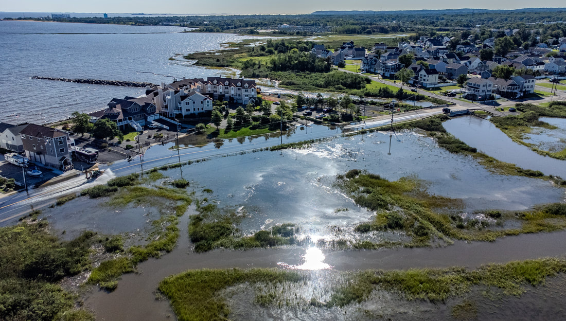
Land use decisions in New Jersey are complicated now and likely to get even more difficult in the future. That's why the state needs an updated development plan.
 
New Jersey is the most populated state in the country, and it has a long coastline. NJ also has many state and local agencies working on real-world application of regulations and standards governing land use. All of that adds additional issues to balancing development priorities, which include affordable housing, urbanization, preservation of open space and natural habitats, economic development, and rising sea levels.
​

While sea levels are rising around the globe, they are rising faster than average along the New Jersey coast thanks to things like subsidence, or the settling of the earth after groundwater is removed, and isostatic rebound, when melting polar ice reduces the amount of weight on certain parts of the earth’s tectonic plates. These factors create a see-saw effect, which lowers the ground elevation in places like New Jersey and raises it in places like Northern Canada. The net result is we’re losing marshland and increasing the amount of flood-prone areas, which means where we build is critical for the safety of humans and wildlife alike. 
 
Last but not least, NJ is on track to be the first state to reach "build out", meaning that every available parcel of land may soon be either developed or preserved.
That's where the New Jersey State Development and Redevelopment Plan comes in, as a coordinator of all of the pieces that go into creation of healthy, prosperous, and resilient communities in the state. Work is currently underway to update that plan.
 
Officially known as the State Plan, this framework could play a pivotal role in coordinating land use planning across NJ's ever-changing landscape to create a sustainable future.
 
However, the first State Plan was legislated nearly 40 years ago, and the current plan was adopted in 2001. Much has changed since then, like increases in precipitation trends, many major storm events (including hurricanes Sandy and Ida), extreme heat waves, and more frequent coastal flooding.
 
These changes do not affect everyone equally. Studies show that people living in poor communities and People of Color are disproportionately impacted by issues related to climate change. Yet the current state plan does not consider equity or climate change, meaning that updates to the 2001 version of the plan are sorely needed. 
 
The State Plan also has to be coordinated with the competing priorities in NJ's current coastal management rules, which include the Coastal Area Facility Review Act or CAFRA and the Tidal Wetlands Act. Among other things, these rules are supposed to “encourage development of compatible land uses” in the coastal area while protecting “the most ecologically sensitive and fragile areas from inappropriate development”. 
 
The coastal management rules attempt to do this by designating land into five separate planning areas, ranging from Urban Centers, which can be up to 90% impervious or built space, to Coastal Environmentally Sensitive Planning Areas, which cannot have more than 5% of the land paved or built on.  These planning areas are intended to be closely coordinated with the State Plan and reflect decisions made by the State Planning Commission during the development of the State Plan.
 
As a result, the State Plan has the potential to result in an increase in the allowed development in coastal areas that should be protected by expanding designated growth zones or to protect climate vulnerable and environmentally sensitive areas and communities by designating them for environmental protection.
 
With all of these entangled priorities, it is extremely important to pay attention to what is being proposed for the State Plan and to tell the State Planning Commission that you want to see the coast protected from harm.
 
The draft of the updated state plan is expected to be released in May 2024, and we will keep you posted on what’s in it and how you can get involved.
James Gater
4/27/2024 09:38:36 am

Very interested in plans to protect our NJ coast line.


Comments are closed.
    BLOG HOME

    Archives

    June 2025
    May 2025
    April 2025
    March 2025
    February 2025
    January 2025
    December 2024
    November 2024
    October 2024
    September 2024
    August 2024
    July 2024
    June 2024
    May 2024
    April 2024
    March 2024
    February 2024
    January 2024
    December 2023
    November 2023
    October 2023
    September 2023
    August 2023
    July 2023
    June 2023
    May 2023
    April 2023
    March 2023
    February 2023
    January 2023
    December 2022
    November 2022
    October 2022
    September 2022
    August 2022
    July 2022
    June 2022
    May 2022
    April 2022
    March 2022
    February 2022
    January 2022
    December 2021
    November 2021
    October 2021
    August 2021
    July 2021
    June 2021
    May 2021
    April 2021
    March 2021
    February 2021
    January 2021
    December 2020
    November 2020
    October 2020
    September 2020
    August 2020
    July 2020
    June 2020
    May 2020
    April 2020
    March 2020
    January 2020
    November 2019
    October 2019
    September 2019
    August 2019
    July 2019
    June 2019
    May 2019
    April 2019
    March 2019
    February 2019
    January 2019
    December 2018
    November 2018
    October 2018
    September 2018
    August 2018
    July 2018
    June 2018
    May 2018
    April 2018
    March 2018
    February 2018
    January 2018
    December 2017
    November 2017
    October 2017
    September 2017
    August 2017
    July 2017
    June 2017
    May 2017
    April 2017
    March 2017
    February 2017
    January 2017

     Subscribe in a reader

    Categories

    All
    5k
    Action
    Advocacy
    Amazon
    Art
    Asbury Park
    Ballot Question
    Barnegat
    Bay
    Beach
    Benefit
    Biomedical
    Breakfree
    Camp
    Celebration
    Cleanup
    Climate
    Coast
    Conservation
    Crafts
    Delaware Bay
    Delbay
    Drilling
    Dune
    Dune Grass
    Earth Day
    Earthday
    Economy
    Eggs
    Election
    Estuary
    Event
    Family
    Fishing
    Fun
    Global Warming
    Horseshoe Crab
    Jamaicabay
    Legislation
    Litter
    Live Music
    Lobster
    Long Beach Island
    Marine Science
    NJ
    NY
    Oil
    Open Space
    Oyster
    Oystere
    Parade
    Party
    Plastic
    Policy
    Pollution
    Protect
    Race
    Rain Garden
    Red Knot
    Reef
    Restoration
    River
    Run
    Sandy Hook
    Shark Fin
    Shell-a-bration
    Shell Bagging
    Shore
    Shorebird
    Summer
    Superstorm Sandy
    Surfcasting
    Tag
    Tagging
    Tourism
    Volunteer
    Wetlands
    Wreck Pond

     Subscribe in a reader

Picture
18 Hartshorne Drive
​Highlands, NJ 07732

What We Do

Education
Conservation
Restoration
Advocacy
Fish Tagging

Where We Work

Sandy Hook
Barnegat Bay
Delaware Bay
Jamaica Bay
Sarasota Bay
National Policy

Who We Are

History
Staff
Officers & ​Trustees
Financials
Contact

Newsroom

Blog
Press Releases
Videos
Publications
Reports

Join Us

Memberships
Donate
Sponsor
Upcoming Events
Field Trips
Volunteer
Jobs
Donate
Membership
Mailing List
Volunteer
Privacy Policy
Copyright ​© 2017, American Littoral Society, All Rights Reserved
Photo from A. Strakey